PIX4Dfields
PIX4Dfields: Fast In-Field Agriculture Mapping And Crop Analysis Software
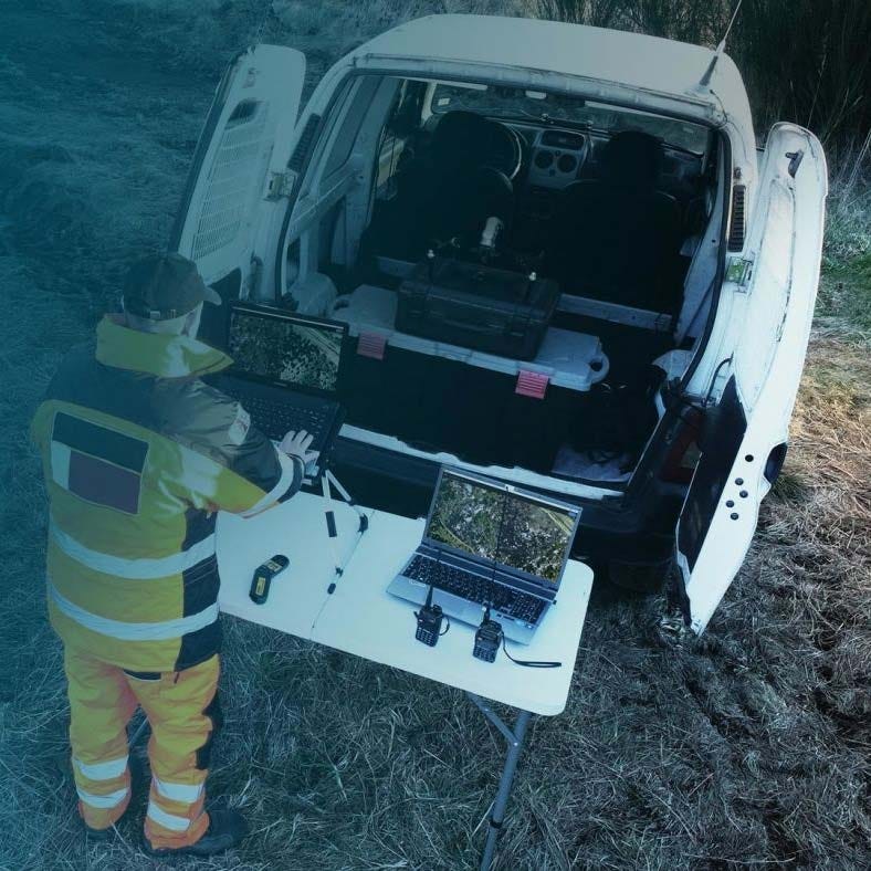
PIX4Dfields is a desktop agriculture mapping software designed for rapid in-field crop analysis and digital farming workflows. It converts nadir RGB and multispectral drone imagery into high-resolution orthomosaics, vegetation index maps, and prescription layers directly on a laptop without requiring internet access.
Optimized for smooth terrain, its direct-to-orthomosaic workflow enables agronomists, service providers, and farm managers to analyze crop health, identify stress zones, and generate actionable application maps while still in the field.
PIX4Dfields Core Features And Operational Advantages
- Offline Processing: Generate high-resolution maps without internet connection.
- Direct-To-Orthomosaic Workflow: Rapid mapping optimized for agricultural terrain.
- Accurate Processing Mode: Produce detailed height models and refined orthomosaics.
- Vegetation Indices: Generate NDVI, NDRE, and additional crop health layers.
- Zonation Tool: Create 2 to 7 management zones from index maps.
- Prescription Mapping: Produce variable rate application maps for precision farming.
- Sentinel-2 Access: Integrate satellite imagery within the platform.
- RTK-Based Positioning: Designed for high-precision agriculture without GCP workflows.
- DJI Agras Compatibility: Export prescription maps directly for Agras T-series drones.
- PIX4Dcloud Integration: Share orthomosaics and index layers to PIX4Dcloud.
PIX4Dfields exists to shorten the time between flight and decision-making. By processing imagery locally and delivering measurable vegetation insights in minutes, it helps agriculture professionals move directly from analysis to action. The result is faster scouting, more targeted applications, and repeatable digital field documentation across growing seasons.
At DSLRPros, we support professional UAS programs in agriculture from aircraft selection through data workflow integration. Ordering PIX4Dfields through DSLRPros ensures your drone operations and digital agronomy tools are aligned with proven field practices and long-term support. Contact DSLRPros to integrate PIX4Dfields into your agriculture mapping program.
PIX4Dfields: Fast In-Field Agriculture Mapping And Crop Analysis Software
PIX4Dfields is a desktop agriculture mapping software designed for rapid in-field crop analysis and digital farming workflows. It converts nadir RGB and multispectral drone imagery into high-resolution orthomosaics, vegetation index maps, and prescription layers directly on a laptop without requiring internet access.
Optimized for smooth terrain, its direct-to-orthomosaic workflow enables agronomists, service providers, and farm managers to analyze crop health, identify stress zones, and generate actionable application maps while still in the field.
PIX4Dfields Core Features And Operational Advantages
- Offline Processing: Generate high-resolution maps without internet connection.
- Direct-To-Orthomosaic Workflow: Rapid mapping optimized for agricultural terrain.
- Accurate Processing Mode: Produce detailed height models and refined orthomosaics.
- Vegetation Indices: Generate NDVI, NDRE, and additional crop health layers.
- Zonation Tool: Create 2 to 7 management zones from index maps.
- Prescription Mapping: Produce variable rate application maps for precision farming.
- Sentinel-2 Access: Integrate satellite imagery within the platform.
- RTK-Based Positioning: Designed for high-precision agriculture without GCP workflows.
- DJI Agras Compatibility: Export prescription maps directly for Agras T-series drones.
- PIX4Dcloud Integration: Share orthomosaics and index layers to PIX4Dcloud.
PIX4Dfields exists to shorten the time between flight and decision-making. By processing imagery locally and delivering measurable vegetation insights in minutes, it helps agriculture professionals move directly from analysis to action. The result is faster scouting, more targeted applications, and repeatable digital field documentation across growing seasons.
At DSLRPros, we support professional UAS programs in agriculture from aircraft selection through data workflow integration. Ordering PIX4Dfields through DSLRPros ensures your drone operations and digital agronomy tools are aligned with proven field practices and long-term support. Contact DSLRPros to integrate PIX4Dfields into your agriculture mapping program.
Original: $349.00
-70%$349.00
$104.70Description
PIX4Dfields: Fast In-Field Agriculture Mapping And Crop Analysis Software
PIX4Dfields is a desktop agriculture mapping software designed for rapid in-field crop analysis and digital farming workflows. It converts nadir RGB and multispectral drone imagery into high-resolution orthomosaics, vegetation index maps, and prescription layers directly on a laptop without requiring internet access.
Optimized for smooth terrain, its direct-to-orthomosaic workflow enables agronomists, service providers, and farm managers to analyze crop health, identify stress zones, and generate actionable application maps while still in the field.
PIX4Dfields Core Features And Operational Advantages
- Offline Processing: Generate high-resolution maps without internet connection.
- Direct-To-Orthomosaic Workflow: Rapid mapping optimized for agricultural terrain.
- Accurate Processing Mode: Produce detailed height models and refined orthomosaics.
- Vegetation Indices: Generate NDVI, NDRE, and additional crop health layers.
- Zonation Tool: Create 2 to 7 management zones from index maps.
- Prescription Mapping: Produce variable rate application maps for precision farming.
- Sentinel-2 Access: Integrate satellite imagery within the platform.
- RTK-Based Positioning: Designed for high-precision agriculture without GCP workflows.
- DJI Agras Compatibility: Export prescription maps directly for Agras T-series drones.
- PIX4Dcloud Integration: Share orthomosaics and index layers to PIX4Dcloud.
PIX4Dfields exists to shorten the time between flight and decision-making. By processing imagery locally and delivering measurable vegetation insights in minutes, it helps agriculture professionals move directly from analysis to action. The result is faster scouting, more targeted applications, and repeatable digital field documentation across growing seasons.
At DSLRPros, we support professional UAS programs in agriculture from aircraft selection through data workflow integration. Ordering PIX4Dfields through DSLRPros ensures your drone operations and digital agronomy tools are aligned with proven field practices and long-term support. Contact DSLRPros to integrate PIX4Dfields into your agriculture mapping program.